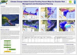
Coastal flooding and sea level rise have been identified by the Government of PNG through the Office of Climate Change and Development (OCCD) as emerging climate change related
impacts and prioritised as a growing threat to PNG, its people and economy. OCCD in collaboration with UNDP commissioned RMSI Private Limited to undertake a comprehensive hazard
assessment arising from coastal flooding for five provinces: East Sepik, Madang, Morobe, Oro and New Ireland. The coastal hazard assessment was part of a larger study developing inland
and coastal hazard assessments for the five provinces commissioned by the Adaptation Fund Programme: Enhancing Adaptive Capacity of Communities to Climate Change-related Flooding
in the North Coast and Islands Region of Papua New Guinea. The hazard assessment is intended to identify the most vulnerable areas in each province and generate information for disaster risk
reduction strategies and planning purposes.